
|
|
|
This site is owned, designed, and operated by Kenneth A. Larson who has over a quarter century of experience in design and construction of scenery for the Entertainment Industry and Theme Parks using Computer Aided and Traditional approaches to Design. Ken also has experience in other areas of Design.
|
|
Select photographs of my many visits to The Missions of the United States South and Southwest built by Spain and Mexico between 1565 and 1823. All photographs taken by Kenneth A. Larson. All rights reserved. © 2008 - 2013. |
| Explanation. |
|
By Founding Date
| ||
|
In the extreme southeast corner of California, far from the more famous chain of twenty-one coastal missions, are two forgotten missions. Or were two missions. The missions of the Colorado River, near present day Yuma, Arizona were short lived and nothing remains except a sketchy record and one historical marker for each. Purísima Concepción, established in October 1780 at Fort Yuma and Mission San Pedro Y San Pablo De Bicuner, founded January 7, 1781, in present day Imperial County were really "Arizona" missions on the California side of the Colorado River and not part of the better known coastal California Mission system. Their short history is closely intertwined. During his travels, Fr. Garcés had become acquainted with Chief Palma, head of the Yuman Indians living in the area along the Colorado River. Palma had embraced Christianity and visited Mexico. Chief Palma asked Garcés to live with the natives and seemed interested in conversion. After some study the king ordered that area be settled. Fr. Garcés strongly recommended against too large a presence. The Yumans, unlike the California Indians who lived off the land, were agriculturalists likely to resent any incursion that would place settlers in the area and appropriate Indian crop land. Unfortunately the commandant general, Carlos de Croix did not listen to Garcés. He ordered that two missions be built, Purisima Concepcion at Fort Yuma and San Pedro y San Pablo at Bicuner. On August 1st, 1779, leaving Padre Diaz with a small escort of soldiers at Sonoita, Padre Garcés started with two soldiers and one other on his last expedition into what is now Arizona. He reached Yuma late in the month, and on September 3rd, sent the soldiers back to Diaz at Sonoita, with the information that he was already having trouble on account of the dissensions among the Yumas. The soldiers reached Diaz, and, at the same time, a Papago reported that some of his nation had revolted and proposed to attack the expedition en route. Captain Palma, a Yuma chief, who had been very friendly, had urged the establishing of missions repeatedly. In 1779, Garcés went to prepare the way, and the following year the establishment took place. Construction began in the fall of 1780. The missions were eight miles apart; one was named La Purisima Concepción; the other, San Pedro y San Pablo de Bicuner. Garcés and Barraneche took charge of Mission La Purísima Concepción, and Diaz and Moreno of San Pedro y San Pablo de Bicuner. From the beginning there were problems. Palma's people had been led to expect better relations with the Spanish than they realized. That first winter, Palma became disaffected and many of his people were in open revolt. Formal orders were issued March 20, 1780 to establish two settlements on the Colorado River. The plan was not for the usual presidio, mission, and pueblo, but an experimental hybrid combining features of all three into something unmanageable. Just as Garces had predicted, the natives resented the white presence and Garcés was given several warnings that the missions would be attacked, which he duly reported. The Yunans finally did attack both missions on Tuesday, July 17, 1781. Garces was saying mass at Concepción to a few people, mostly women, when the attacks started. While the killings and looting was occuring, both priests heard confession and administered the sacrament to some of the dying. The same day the Indians attacked Padres Diaz and Moreno at Bicuner as they were preparing to say mass, and they, and most of the soldiers, were killed in the attack. Through the influence of Palma, Garcés and Father Barranche survived until the 19th when they were both beaten to death with clubs. The bodies of the four priests were afterwards recovered and laid to rest in one coffin in the church at Tubutama. |
 Mission Puerto de Purísima Concepción |
 Mission San Pedro y San Pablo de Bicuner |
Puerto de Purísima Concepción, established in October 1780, by Padres Juan Antonio Barreneche and Francis Tomás Hermenogildo Garcés. Winterhaven/Fort Yuma. |
Personal ObservationsTwo missions were established along the Colorado River near present day Yuma Arizona. There is debate as to status of these sites as true missions and they did not last long. Today, nothing exists of these missions except markers. One mission site, Mission La Purisima Conception de la Virgen Santisima, by coincidence or more likely because of a commanding hill top location, is now home to a Catholic church, but it has not been in continuous occupation by a church. It was for an intervening time, the site of Fort Yuma. I read a brief account of this mission about six months before my visit and began planning a trip to Yuma. |
Mission Art & Photo-Art |
|
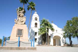
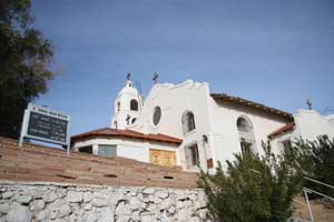
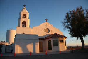
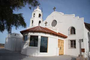
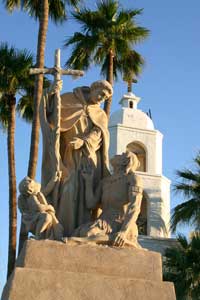
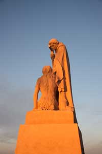
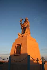
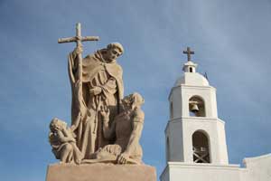
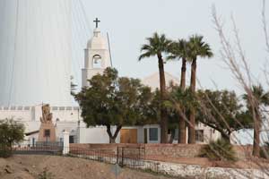
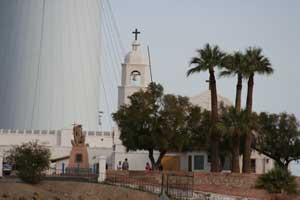
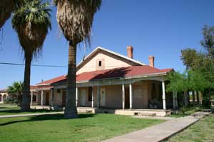
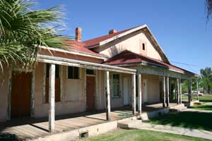
The first mission at Ft. Yuma was named Puerto de la Purísima Concepción, established in 1780, built by Father Francisco Garcés. The mission/pueblo site was inadequately supported. Colonists ignored Indian rights, usurped the best lands, and destroyed Indian crops. Completely frustrated and disappointed, the Quechans (Yumas) and their allies destroyed Concepción on July 17-19, 1781. On July 17, 1781, the Spanish Padres, settlers, and soldiers at that place and at San Pedro y San Pablo de Bicuner, 8 leagues up the Colorado river, were all massacred. Fort Yuma (1849-1885) became a U.S. military outpost in the 19th century and was revived as an active mission again in 1919. The current church, St. Thomas Indian Mission, was dedicated in 1923. The Mission was located on the California side of the Colorado River near where the Gila River joins the Colorado on Indian Hill. Times Open: The mission is closed during the week, but staff will accept visitors who make arrangements beforehand by calling (760) 572-0283. The mission is San Diego's eastern-most parish. Mass times are Sat. 4:30 and Sun. 9:30 a.m. June-Sept., otherwise 10:30 a.m. Reconciliation is Saturday 3:30-4:30 p.m. Although the Mission is in California and on Pacific Time, because of its proximity to Yuma, it generally operates on Mountain Standard Time. California Historical Landmark No. 350. In the forcourt of the church is a statute of Padre Garcés. Location: St. Thomas Indian Mission, Indian Hill on Picacho Rd, Fort Yuma, 1 mi S of Winterhaven Location: St. Thomas Indian Mission is at Fort Yuma, California at the extreme southeast corner of California. Fort Yuma, California, Colorado River's west bank, opposite the present city of Yuma, Arizona. Take Interstate 8 almost to the Arizona border. After the check station, turn off on Winterhaven. Turn left on 4th Ave. When you come to a sign that reads "To Bard," turn right. At the fork in the road, go right. Turn left at the dead end and you will come to the church. It's actually easier than these directions sound. From the Arizona side, cross the Ocean to Ocean bridge and turn right. And there it is. It's on top of the only hill in the area and easily visible from a distance. |
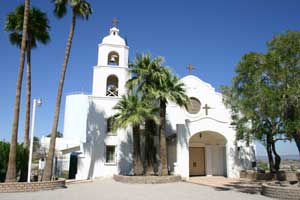 St. Thomas Indian Mission. Photo date: 3-12-05. |
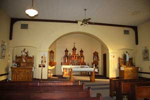
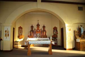
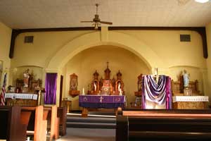 St. Thomas Indian Mission, interior. Photo date: 3-13-05. |
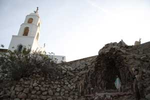
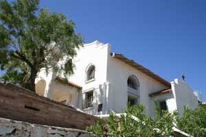 Saint Thomas Indian Mission from below. Photo date: 3-12-05. |
 Note the new entry vestibule in 2009. |
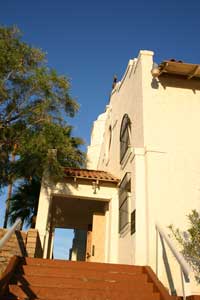 Saint Thomas Indian Mission from below. Photo date: 3-13-05. |
|
 |
|
Note these photos from 2009 show a new entry vestibule. | |
|
Statute of Padre Garcés with Saint Thomas Indian Mission beyond. Photo date: 3-12-05. |
 Statute of Padre Garcés with Saint Thomas Indian Mission beyond. Photo date: 3-13-05. |
 As seen from Yuma Prison. 2005. |
 As seen from Yuma Prison. 2009. |

|
|
 |
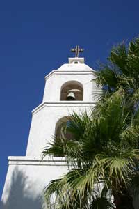 Bell tower. Photo date: 3-12-05. |
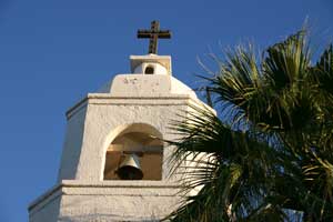 Bell tower. Photo date: 3-13-05. |
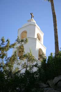 Bell tower. Photo date: 3-13-05. |
 Saint Thomas Indian Mission interior. Photo date: 3-13-05. |
|
|
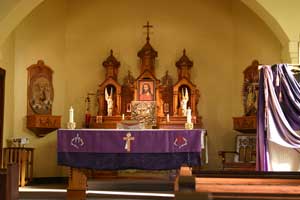
| The front and altar of the interior of the Church in 2009. | |
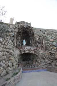
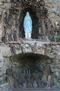 Grotto to Our Lady. Photo date: 3-13-05. |
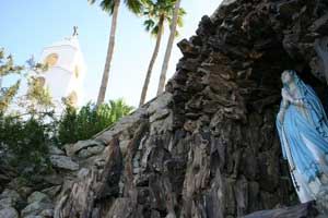 Grotto to Our Lady. Photo date: 3-13-05. |
 Grotto to Our Lady. Photo date: 3-13-05. |
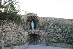
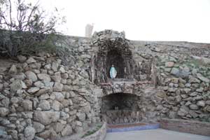 Grotto to Our Lady. Photo date: 2-15-09. |
 Grotto, 2009. |
 Grotto and Church, 2009. |
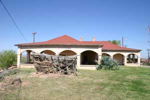 Quechan Museum. Photo date: 3-12-05. |
 Quechan Museum. Photo date: 3-12-05. |
 Quechan Museum. Photo date: 3-12-05. |
 Quechan Museum. Photo date: 3-12-05. |
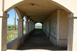
 Quechan Tribal Facility Building. Photo date: 3-12-05. |
 Quechan Tribal Facility Building. Photo date: 3-12-05. |
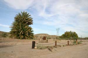 Photo date: 3-13-05. |
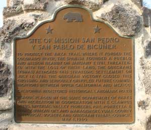 Photo date: 3-13-05 |
|
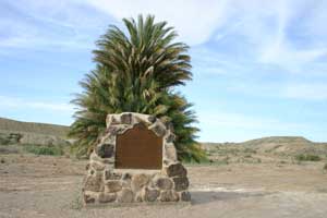
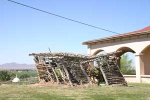
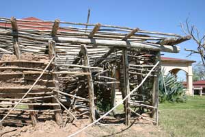
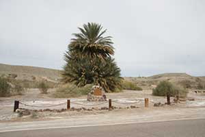
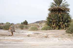
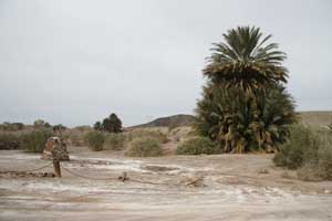
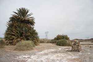
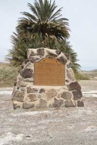
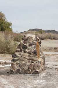
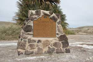
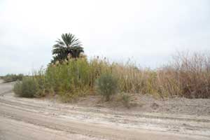
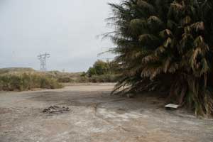
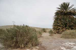
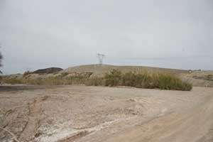
Mission San Pedro y San Pablo (Saint Peter and Saint Paul) de Bicuner was one of the two Missions established on the west side of the Colorado River near present day Yuma, Arizona. Founded on January 7, 1781, it was short lived being destroyed on July 17, 1781 by Quechans (Yumas) who were dissatisfied with treatment by the Spanish. The Missions didn't exist long enough to build much and little remains. The Mission was established to protect the Anza Trail where it forded the Colorado River. The destruction of the Mission closed this crossing and seriously crippled future communications between upper California and Mexico. The location is open to debate. Several accounts state that the site of Mission San Pedro y San Pablo is located 8 leagues down river from Purísima Concepción near Fort Defiance about half a mile above the Mexican Border. Several maps show this. There are also accounts stating that the site of Mission San Pedro y San Pablo is located 8 leagues up river from Purísima Concepción. There are maps that show this northern location. The road side marker is at the up river location. In correspondence with Phil Porretta, he presents good reason to believe that the northern location (upriver and where the marker is) is correct. Marker location: On County Rd S24, 0.2 mi W of intersection of Levee and Mehring Rds, 4.4 mi NE of Bard S24, near Coles Corner, about a mile west of the Colorado River, and a few miles south of Laguna Dam. NO. 921 Site of Mission San Pedro y San Pablo de Bicuner. |
|
Photo date: 3-13-05. |
Photo date: 3-13-05. |
|
|
| The site beside County Road S24 in 2009. | |
|
|
| The site beside County Road S24 in 2009. | |
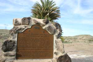 Photo date: 3-13-05. |
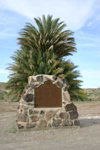 Photo date: 3-13-05. |
|
|
| The Marker is easily seen from the road. 2009. | |
|
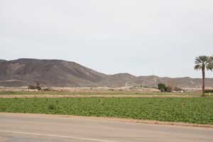 The Mission is at the base of these distant hills. |
 |
|
| Looking back in the direction of the marker from behind the trees. | |
 Looking back toward the marker.
|
 Looking further back from behind the trees and marker. 2009. |
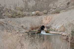 Water draining an area behind the site. 2009. |
|
By Founding Date
| ||

|

|

|
| Note:This is not the official site for any of the places shown in US Mission Trail. US Mission Trail is not responsible for accuracy of the information. Hours of operations, prices, and exhibits are subject to change without notice. |
|
Support this Web Site I hope that you find this web site helpful. It started because of my love for the California Missions and interest in History and a desire to share my photographs and tales of my adventures. I don't allow paid advertising. This web site is for your benefit and enjoyment and I make no profit on it. For twenty years it has been supported primarily from my regular paycheck as a Set Designer. A non-tax deductable donation helps cover the cost of operating this web site and may be made to Kesign Design Consulting through PayPal. | ||
|
If you are in the need of a designer, please see my Set Designer portfolio site Set Design Portfolio. |
| Or donations can be mailed to the address on the contact page. |
|
Links
Home |
Contact |
Sales |
Ken Larson |
K L Images |
Places Earth
|

|
This site maintained by Kenneth A. Larson. Copyright © 2004 - 2023, Kenneth A. Larson. All Rights Reserved. Website content including photographic and graphic images may not be redistributed for use on another website. |

|

|

|